By Anh - Silvera Food
Fri, Jul 12 2019, 18:00 (GMT + 7)
We had a post before that the Mekong Delta consists of 12 provinces and 1 city. So today, let's discover some interesting things about each of them. It is going to be fun!
The figures and information in this post are based on this article from https://mientaynambo.com/cac-tinh-mien-tay-nam-bo/.
Long An Province
 |
| Tan Lap Floating Village in Long An Province. Credit: namthientravel.com |
Long An is a province in the Mekong Delta, belonging to the Southern key economic region of Vietnam and also acting as the gateway connecting the Southeast region (including Ho Chi Minh City) and the Mekong Delta.
This province is adjacent to Ho Chi Minh city, sharing the transport system with this city with several important routes such as National Route 1A, and National Route 50.
Long An is also considered as the largest market for agricultural products of the Mekong Delta.
Total area: 4,491.90 km²
Population in 2013: 1,469,900 people
Administrative units: 1 city (Tan An City), 1 town and 13 districts
Population in 2013: 1,469,900 people
Administrative units: 1 city (Tan An City), 1 town and 13 districts
Tien Giang Province
 |
| Tan Thanh Beach in Tien Giang Province. Credit: vietnammoi.vn |
Full name in Vietnamese is Tỉnh Tiền Giang, in which "Tỉnh" means "Province".
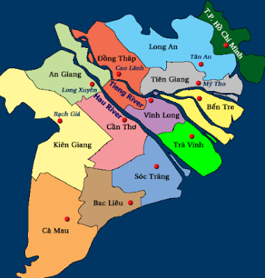
Tien Giang is a province in the Mekong Delta, belonging to the Southern key economic region, 70 km away from Ho Chi Minh City to the South and 90 km away from Can Tho City to the North. In terms of administrative borders, Tien Giang borders East Sea to the East, Long An and Ho Chi Minh City to the Northeast, Dong Thap to the West, Ben Tre and Vinh Long to the South. If you feel a bit lost, the below photo should help you visualize the directions better.
 |
| Locations of provinces and city in the Mekong Delta. Credit: mientaynambo.com |
Total area: 2,508.6 km²
Population in 2014: 1,716,086 people
Administrative units: 1 city (My Tho City), 2 towns and 8 districts
Administrative units: 1 city (My Tho City), 2 towns and 8 districts
Vinh Long Province
 |
| My Thuan Bridge opened on May 21, 2019 with the total length of 1,535 meters connects Tien Giang and Vinh Long. Credit: tuoitre.vn |
Full name in Vietnamese is Tỉnh Vĩnh Long, in which "Tỉnh" means "Province".Vinh Long Province is located right between the two main branches of Mekong River, which are Tien River and Hau River. From above, Vinh Long looks like the center of the Mekong Delta map.
Vinh Long is geographically adjacent to Ben Tre to the East, Tra Vinh to the Southeast, Can Tho to the West, Dong Thap to the Northwest and Tien Giang to the North.
Total area: 1,520.2 km²
Population in 2013: 1,040,500 people
Administrative units: 1 city (Vinh Long City), 1 town and 6 districts.
Population in 2013: 1,040,500 people
Administrative units: 1 city (Vinh Long City), 1 town and 6 districts.
Ben Tre Province
 |
| Coconut garden in Ben Tre Province. Credit: baodongkhoi.vn |
Ben Tre is located at the end of the downstream of the Mekong River, adjacent to East Sea with the coastal path of up to 65 km. The center of Ben Tre is 87 km away from Ho Chi Minh City. Its North is contiguous with Tien Giang, its West with Vinh Long, its South with Tra Vinh and its East with East Sea.
Total area: 2,359.5 km²
Population in 2013: 1,262,000 people
Administrative units: 1 city (Ben Tre City) and 8 districts
Population in 2013: 1,262,000 people
Administrative units: 1 city (Ben Tre City) and 8 districts
Dong Thap Province
 |
| Tram Chim National Park in Dong Thap Province. Credit: truyenhinhdulich.vn |
Full name in Vietnamese is Tỉnh Đồng Tháp, in which "Tỉnh" means "Province". The border between Dong Thap and Cambodia is approximately 50 km long with 4 crossings, among which there are 2 International crossings named Thuong Phuoc and Dinh Ba.
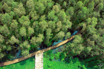
Dong Thap, one of the 13 provinces and city in the Mekong Delta, is located at the upstream of the Tien River and is well-known for its Thap Muoi Lotus Field and Tram Chim National Park. Dong Thap borders Long An to the North, Preyveng Province (Cambodia) to the Northwest, An Giang and Can Tho to the South.
Total area: 3.378,8 km²
Population in 2013: 1,680,300 people
Administrative units: 2 cities (Cao Lanh City and Sa Dec City), 1 town and 9 districtsTra Vinh Province
 |
| Tra Vinh Province. Credit: tuyengiao.vn |
Full name in Vietnamese is Tỉnh Trà Vinh, in which "Tỉnh" means "Province". Tra Vinh is a province in the Mekong Delta, 95 km away from Can Tho City and 170 km away from Ho Chi Minh City towards National Route 1A. However, travelling towards Co Chien Bridge (National Route 60) from Tien Giang to Tra Vinh would reduce the distance from Ho Chi Minh City to Tra Vinh to only 100 km.
Tra Vinh is surrounded by Tien River and Hau River with two river gates Cung Hau and Dinh An encouraging the development of awaterway.
Tra Vinh is a coastal province in the Mekong Delta, with its South adjacent to Soc Trang, its North to Ben Tre, its West to Vinh Long and its East to East Sea with a coastal path of 65 km.
Total area: 2,341.2 km²
Population in 2010: 1,012,600 people
Administrative units: 106 wards, hamlets and towns
Full name in Vietnamese is Tỉnh An Giang, in which "Tỉnh" means "Province". An Giang is a famous place in the Mekong Delta for its Sam Mountain in Chau Doc City, bordering Dong Thap to its East and North, Cambodia to its Northwest, Kien Giang to its South and Southwest and Can Tho to its Southeast.
An Giang Province
 |
| Tra Su Forest in An Giang Province. Credit: shutterstock.com/Jindowin |
Full name in Vietnamese is Tỉnh An Giang, in which "Tỉnh" means "Province". An Giang is a famous place in the Mekong Delta for its Sam Mountain in Chau Doc City, bordering Dong Thap to its East and North, Cambodia to its Northwest, Kien Giang to its South and Southwest and Can Tho to its Southeast.
Total area: 3,424
km²
Population in 2011: 2,151,000 people
Administrative units: 2 cities (Long Xuyen City and Chau Doc City), 1 town and 8 districts
Population in 2011: 2,151,000 people
Administrative units: 2 cities (Long Xuyen City and Chau Doc City), 1 town and 8 districts
Can Tho City
 |
| Can Tho Bridge in Can Tho City. Credit: shutterstock.com/LocHuynh |
Full name in Vietnamese is Thành phố Cần Thơ, in which "Thành phố" means "City". Can Tho City, the
central city of the South Western Region, is located at the center of the
Mekong Delta and the downstream of the Mekong River and is renowned for Ninh
Kieu Wharf and Can Tho Bridge.
Can Tho is 169 km away from Ho Chi Minh City, 120 km away from Rach Gia City (Kien Giang Province) and 150 km away from Ca Mau City.
Can Tho neighbours An Giang to the North, Kien Giang to the West, Hau Giang to the South, Dong Thap and Vinh Long to the East.
Total area: 1,409 km²
Population in 2013: 1,224,100 people
Administrative units: 5 districts and 4 wards
Full name in Vietnamese is Tỉnh Hậu Giang, in which "Tỉnh" means "Province".
Hau Giang is one of the Mekong Delta provinces with its West bordering Kien Giang, its East bordering Soc Trang, its North bordering Can Tho and Vinh Long, and its South bordering Bac Lieu.
Total area: 1,602.4 km²
Population in 2013: 773,800 people
Administrative units: 1 city (Vi Thanh City), 2 towns and 5 districts
Bac Lieu is located on the Ca Mau Peninsula, neighbouring Hau Giang to the North, Soc Trang to the East and Northeast, Ca Mau to the Southwest, Kien Giang to the Northwest and East Sea to the Southeast with a coastal path of up to 56 km.
Total area: 2,526 km²
Population in 2013: 876,800 people
Administrative units: 1 city (Bac Lieu City), 1 town and 5 districts
Soc Trang is adjacent to Vinh Long to the North, Hau Giang to the Northwest, Bac Lieu to the Southwest, Tra Vinh to the Northeast, East Sea to the East and Southeast.
Kien Giang is renowned among young Vietnamese travellers for its stunning irresistible beauty at U Minh National Park, Phu Quoc Island or Nam Du Island.
Total area: 6,348.5 km²
Population in 2013: 1,738,800 people
Administrative units: 2 towns and 11 districts
And congratulations! You have reached the end of this post. Thank you for being such a patient reader. We truly hope you find this post informative and helpful.
If you like it and want more people to know of it, feel free to share! :)
Have a nice day!
Can Tho is 169 km away from Ho Chi Minh City, 120 km away from Rach Gia City (Kien Giang Province) and 150 km away from Ca Mau City.
Can Tho neighbours An Giang to the North, Kien Giang to the West, Hau Giang to the South, Dong Thap and Vinh Long to the East.
Total area: 1,409 km²
Population in 2013: 1,224,100 people
Administrative units: 5 districts and 4 wards
Hau Giang Province
 |
| Hau Giang Province. Credit: Wikipedia |
Hau Giang is one of the Mekong Delta provinces with its West bordering Kien Giang, its East bordering Soc Trang, its North bordering Can Tho and Vinh Long, and its South bordering Bac Lieu.
Total area: 1,602.4 km²
Population in 2013: 773,800 people
Administrative units: 1 city (Vi Thanh City), 2 towns and 5 districts
Bac Lieu Province
 |
| Farm of wind turbines in Bac Lieu Province. Credit: chooose.today |
Total area: 2,526 km²
Population in 2013: 876,800 people
Administrative units: 1 city (Bac Lieu City), 1 town and 5 districts
Soc Trang Province
 |
| Floating market in Soc Trang Province. Credit: doanhnhansaigon.vn |
Full name in Vietnamese is Tỉnh Sóc Trăng, in which "Tỉnh" means "Province"
Soc Trang is geographically situated at the Nam gate of the Hau River, approximately 231 km away from Ho Chi Minh City and 62 km away from Can Tho. It is also positions itself on the important National Route 1A connecting several provinces, namely Hau Giang, Can Tho, Bac Lieu and Ca Mau.Soc Trang is adjacent to Vinh Long to the North, Hau Giang to the Northwest, Bac Lieu to the Southwest, Tra Vinh to the Northeast, East Sea to the East and Southeast.
Total area: 3,223.30 km2
Population in 2013: 1,303,700 people
Administrative units: 1 city (Soc Trang City), 2 town, 8 districts
Population in 2013: 1,303,700 people
Administrative units: 1 city (Soc Trang City), 2 town, 8 districts
Kien Giang Province
 |
| Nam Du Island at sunset. Credit: shutterstock.com/LocHuynh |
Full name in Vietnamese is Tỉnh Kiên Giang, in which "Tỉnh" means "Province". Kien Giang, a province located to the Southwest of Vietnam in the Mekong Delta, sharing a border of around 56 km with Cambodia, possesses a coastal path of more than 200 km, bordering Can Tho and An Giang to the East and Southeast, Ca Mau and Bac Lieu to the South, Gulf of Thailand to the West.
Kien Giang is renowned among young Vietnamese travellers for its stunning irresistible beauty at U Minh National Park, Phu Quoc Island or Nam Du Island.
Total area: 6,348.5 km²
Population in 2013: 1,738,800 people
Administrative units: 2 towns and 11 districts
Ca Mau Province
 |
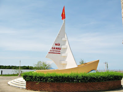
| The monument in Ca Mau Province marking the Southern tip of Vietnam. Credit: canhdep.net |
Full name in Vietnamese is Tỉnh Cà Mau, in which "Tỉnh" means "Province". Ca Mau is the Southern tip of Vietnam with 3 directions touch the sea, its East is adjacent to East Sea, its West and South to Gulf of Thailand, its North to Bac Lieu and Kien Giang.
Total area: 5.294,9 km²Population in 2013: 1,219,900 people
Administrative units: 1 city (Ca Mau City) and 8 districts
Its system of numerous canals and rivers includig big ones such as Mekong River, Tien River, Hau River, Ham Luong River, Vam Co Dong River, Vam Co Tay River, and so on allows the area to accumulate plenty of fertile silt, encouraging the development of agriculture in Ca Mau and the Mekong Delta.
Its system of numerous canals and rivers includig big ones such as Mekong River, Tien River, Hau River, Ham Luong River, Vam Co Dong River, Vam Co Tay River, and so on allows the area to accumulate plenty of fertile silt, encouraging the development of agriculture in Ca Mau and the Mekong Delta.
And congratulations! You have reached the end of this post. Thank you for being such a patient reader. We truly hope you find this post informative and helpful.
If you like it and want more people to know of it, feel free to share! :)
Have a nice day!
Silvera Food Trading Co., Ltd
Telephone: +84 937 968 548
Address: 202 Le Lai Street, Ben Thanh Ward, District 1, Ho Chi Minh City, Vietnam
Telephone: +84 937 968 548
Address: 202 Le Lai Street, Ben Thanh Ward, District 1, Ho Chi Minh City, Vietnam
Email: info@silverafood.com

Comments
Post a Comment